Page 1 of 1

ReDEM being weird

Unread postPosted: Wed Jul 14, 2010 10:16 pm
by Shortliner
So I brought ReDEM to map out the terrain for my route. However what I'm getting for Suggest DEM bounds is weird, maybe someone can tell me what I'm doing wrong?

Image

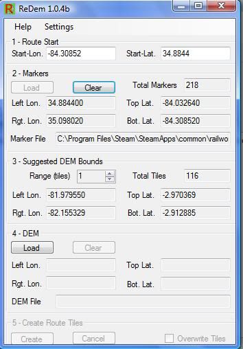
I've attached my series file for y'all to look at. Maybe I made a mistake somewhere?

Re: ReDEM being weird

Unread postPosted: Wed Jul 14, 2010 10:44 pm
by Trainguy76
I think ReDEM has an issue with DEM across multiple latitudes/longitudes.

Try doing it within one lat/long to check if that's true?

Re: ReDEM being weird

Unread postPosted: Wed Jul 14, 2010 11:35 pm
by Bananarama
Me thinks your marker file is goofed up.

Re: ReDEM being weird

Unread postPosted: Thu Jul 15, 2010 3:58 pm
by Shortliner
Hack wrote:Me thinks your marker file is goofed up.


Maybe. I went to the Abandoned Rails website and contacted the guy to see if he can help me map out one of the routes I saw on his website. He e-mail me the cords for the markers and I fixed it up to where RW could read it and saved it as a .csv. I may have to go back and do it again.

Re: ReDEM being weird

Unread postPosted: Thu Jul 15, 2010 7:36 pm
by qrfan3
Shorty

Marc is correct in that the .csv file is goofed......just back to front I suspect. I downloaded your .csv file and it appears to have maybe correct values, but column A should be the long values and column B should be the lat values. I swapped them around and noted your start point......around Blue Ridge is it ???

My results after swapping:

murphy.jpg


Hope this helps you some.
!*cheers*!

Re: ReDEM being weird

Unread postPosted: Thu Jul 15, 2010 9:49 pm
by Shortliner
qrfan3 wrote:Shorty

Marc is correct in that the .csv file is goofed......just back to front I suspect. I downloaded your .csv file and it appears to have maybe correct values, but column A should be the long values and column B should be the lat values. I swapped them around and noted your start point......around Blue Ridge is it ???

My results after swapping:

murphy.jpg


Hope this helps you some.
!*cheers*!


Ok so I just switch the columns and everything should be peachy. Thanks!

Yea, there was a shortline that ran from Blue Ridge GA to Murphy NC. Here's the link on it.

http://www.abandonedrails.com/Murphy_Junction_to_Murphy

That's what I'm trying to model.

Re: ReDEM being weird

Unread postPosted: Thu Jul 15, 2010 11:31 pm
by qrfan3
YW...I will keep an eye out for your WIP..... !!*ok*!!

Cheers.

Re: ReDEM being weird

Unread postPosted: Fri Jul 16, 2010 3:37 am
by Hawk
That line now runs excursions from Etowah to Blue Ridge and back, through the hook and eye.
It's a nice train ride. I've got some pictures of it when a few of us from the old MSTS Atlanta group took the trip. I believe it was the first excursion they ran on that line after some moderate re-construction.

Re: ReDEM being weird

Unread postPosted: Fri Jul 16, 2010 6:48 am
by Shortliner
Hawk wrote:That line now runs excursions from Etowah to Blue Ridge and back, through the hook and eye.
It's a nice train ride. I've got some pictures of it when a few of us from the old MSTS Atlanta group took the trip. I believe it was the first excursion they ran on that line after some moderate re-construction.


Ahh cool, I may have to model that next. :)

Re: ReDEM being weird

Unread postPosted: Fri Jul 16, 2010 7:04 am
by Hawk
I was thinking you're were doing the old L&N hook & eye line, but I think now that you're doing the old line going up to the east from Blue Ridge, part of the old Marietta and North Georgia line.

When I did have Railworks installed I had started working on the current Georgia Northeastern line form Elizabeth, GA (where it ties in with the CSX W&A Sub) to Tate, GA, which is part of the old MNG. The track still runs from Tate to Blue Ridge but is seldom used.
The Blue Ridge Scenic Railway uses GNR power for their excursions.

If you're interested, here's a short article about the GNR. http://hawkdawg.com/rrhist/motir/